Many travelers I talk to only have a few days in Iceland so they usually just stick to Route 1 (the ring road). In that case, I highly recommend checking out some of the more popular attractions, like the Blue Lagoon, Myvatn Nature Baths, Jokulsarlon glacial lagoon, the Golden Circle, and other popular tourist places close to Route 1. Doing the Golden Circle and then driving along the south coast is a very popular choice, for example. But for those who want to get the most out of their experience in Iceland, going off the beaten path is a must. When friends, family, and travelers ask me about my favorite attractions, I point to these hidden gems:
Seljavallalaug
What: Seljavallalaug is the oldest swimming pool in Iceland, built in 1923. It is built around a natural hot spring, heated by the same power that caused the infamous volcanic eruption in Eyjafjallajökull. Bathing by the foot of the glacier, surrounded by the raw Icelandic nature is truly an amazing experience. It is minimally maintained, with no showering facilities, but that just adds to its charm if anything. Pro tip: try claiming the spot where the hot water runs into the pool (on the bottom right of the photo below), especially if it’s a bit chilly outside. I found that the water temperature is slightly below perfect.
Where: Driving east on Route 1 from Reykjavík, past Selfoss and Hvolfsvollur, turn at Seljavellir farm (clearly marked), take that road as far as it will take you and park your car. From there, the pool is about 10-15 minute hike away. It might take a short hike to get there, but once you’re there, you will not want to leave.
Gjáin
What: Gjáin is a small canyon that formed thousands of years ago. It is truly an oasis hidden in southern Iceland, surrounded by vast fields of pumice from Hekla volcano. The biggest ash eruption in Iceland history occurred in this area in 1104 AD, destroying a flourishing farming community. The river Rauðá (Red river) flows through the canyon and nourishes the rich vegetation in the area. You will also see some beautiful waterfalls there, the largest being Gjáfoss.
Where: Gjáin is towards the bottom of Þjórsárdalur valley, which lies between mount Búrfell alongside the river Þjórsá (Iceland’s longest river) to the east and mount Skriðufell to the west. From the historical farm Stöng, Gjáin is within half an hour walking distance. The area is great for hiking but you can access it by taking route 32 and then turning onto road 327 (Stangarvegur).
Háifoss
What: Háifoss is the second tallest waterfall in Iceland at 122m. Aside from its size, what makes this waterfall special is that it’s accompanied by another waterfall, Granni (neighbor). The river Fossá, a tributary of Þjórsá, drops here and is surrounded by the barren, but beautiful Icelandic nature. If you appreciate the raw Icelandic nature, you will definitely enjoy this spot.
Where: Just like Gjáin, Háifoss is located in Þjórsárdalur valley. It can be quite difficult to get there by car, so we don’t recommend traveling there if you do not drive a 4×4 vehicle. From the farm Stöng, it is a 5-6 hour hike each way, but for adventurous hikers, it is definitely worth it!
Strandir
What: Strandir (literally meaning the coasts), is a region covering the eastern part of the Westfjords, from north to south. This has been the most remote area of Iceland for centuries and currently has less than 800 inhabitants. Driving up and down the coast is truly a unique experience, as it’s characterized by a feeling of isolation and stillness. One of the towns in this area, Djúpavík, is a particularly interesting place. It is very remote and untouched by modern developments. It is a former fishing town and you will find a large abandoned herring pickling factory there, built in the early 20th century. The landscape is rugged and the town is surrounded by steep mountains. It is quite difficult to describe its magical atmosphere, so just do yourself a favor and put it on your list. Another place you must stop by is Krossneslaug, a pool heated by natural hot springs. It is located right on the coast, so you can experience the roaring waves of the Atlantic ocean right next to you while you relax in a warm geothermal pool. Yes, please.
If you are up for some even greater adventures (and hiking), you should also check out the Hornstrandir Nature Reserve. Almost no humans live in this large (580 square km) area and it’s full of beautiful landscapes and rich vegetation. If you want to see the extreme “desolate” side of Icelandic nature, you won’t be disappointed by this experience. Check out this excellent post by @for91days about their experience at Hornstrandir.
Where: Strandir is a district in the northwest of Iceland. You simply follow Route 1 to Brú in Hrútafjörður, turn onto Road 61, and then turn right onto Road 643 in another 112 km. You will get to Djúpavík after 60 km on this road, and Krossneslaug is located in Krossnes, a little bit farther north of Djúpavík.
Aldeyjarfoss
What: Aldeyjarfoss is a waterfall in the Icelandic highlands, fed by the glacial river Skjálfanafljót. The river originates in Vatnajökull, the largest glacier in Europe. This waterfall is considered to be one of the most beautiful ones in Iceland, particularly because of the magnificent contrasts of the black basalt rocks and the white glacial water. The waterfall is framed with long, natural basaltic columns and even though it is a little “out of the way” most people we talk to tell us that it is well worth the trip.
Where: Aldeyjarfoss is located in the northern Highlands of Iceland. This means that it is a part of the Iceland highlands, so only those who have a 4×4 car can drive there. From Akureyri, you drive about 50 km east on Route 1, turn right onto Route 842 and follow it about 37 km. That’s when you officially enter the highlands and get on Route F-26, which you follow for about 4 km until you reach Aldeyjarfoss.
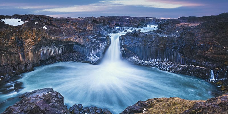 Aldeyjarfoss Falls at Sunrise shows the water pouring over the edge and kicking up a misty cloud over the water.
Asbyrgi National Park
What: Many people are aware of Ásbyrgi; after all, it is a national park. However, it is located some ways off Route 1 so many people do not go there unless they are driving the Diamon Circle. Ásbyrgi is a large horseshoe-shaped canyon with cliffs up to 100 m high. It is 3.5 km long and 1 km wide, with a small pond located at its innermost part. It’s an unbelievably peaceful and beautiful place; it’s the perfect oasis in the north! According to legend, Odin’s eight-legged horse, Sleipnir, stepped down there when the God was riding.
Where: Ásbyrgi is the northernmost part of Jokulsargljufur National Park and lies in the north of Iceland. From Route 1, you turn onto Route 864 towards Dettifoss, the most powerful waterfall in Europe. From Dettifoss, you will drive for about 85 km, turn left onto Route 85 until you see signs for Asbyrgi.
Dyrfjoll Mountains
What: This mountain is one of the east’s major symbols. It contains a gorgeous trail with clear pools, beautiful rivers, and glaciers, and of course, the view from the peak is magnificent! It is known for the large gap in the middle of the mountain, but if you follow Route 1 you will miss this beautiful mountain area in the East. Aside from the beautiful scenery, the region is known for stories about elves and apparently, the elf queen resides there. She lives in Álfaborgir (Elf City) in Borgarfjordur Eystri, close to Dyrfjoll.
Where: Dyrfjoll stands between Fljotsdalsherad and Borgarfjordur Eystri. You can reach the area by car by taking Route 94, off of Route 1 in the east.
Siglufjordur
What: Siglufjordur is a small fishing town, located in a fjord with the same name (fjordur means fjord in Icelandic) on the northern coast of Iceland. The town was largely built around the herring industry that thrived there in the 1940s and 50s, although the herring is gone today. Siglufjordur is a small and charismatic town and is the northernmost town in Iceland. The fjord is surrounded by tall mountains and the landscape is truly breathtaking. Also, Siglufjordur has grown significantly as a cultural center in the past decade. For example, it hosts the third largest museum in the nation, The Herring Era Museum, and has won prestigious awards. It has some lovely coffee shops and definitely worth a visit!
Where: Siglufjordur is located in the northern part of Iceland, southwest of Akureyri. From Route 1, you can take Route 82 if you’re coming from east, but Route 76 if you’re coming from the west, until you reach Siglufjordur in the north.
Kvernufoss
What: Most people plan on stopping by the beautiful Skogarfoss in the south. Much fewer make an effort, or simply don’t know about the picturesque Kvernufoss waterfall. It lies at the bottom of a stunning gorge, making the hike there quite enjoyable. It’s a perfect place to get away from the tourist crowd (you might have to hang out with some sheep though), relax, and possibly enjoy a picnic with the waterfall in the background. The waterfall is approximately 30 m tall and you can walk behind it, which is always fun. In that sense, it’s just a slightly smaller (and perhaps more beautiful) version of the popular Seljalandsfoss waterfall.
EDIT: Since I wrote this post, my fellow happy camper, and colleague, Michael, wrote this post about Kvernufoss. Turns out it’s one of his favorite places too. Check it out.
Where: From Route 1, turn off the road at Skógar and make the first right possible. This should take you to the Museum of Skógar. From there, just park your car and start walking towards the river straight ahead, follow the river to the gorge, and find the waterfall. More details in Michael’s post that I mentioned above.
Reykjadalur
What: Reykjadalur is an unspoiled valley, characterized by geothermal activity and hot springs. Reykjadalur means “smoke valley”, getting its name from the geothermal activity of the area. This place is often overlooked as it’s only about 40 minutes away from Reykjavík and people race through the area towards some of the more popular destinations in the south. There are bathing areas there where you can relax in a natural hot spring, surrounded by the beautiful Icelandic landscape. What we like about this place is that it’s completely unspoiled; no shops, no changing rooms, or tourist information. Getting there takes a short hike, but the paths are clearly marked so it’s difficult to get lost and it’s definitely worth it! We hope you don’t mind the smell of sulfur though.
EDIT: Since I wrote this post originally, Reykjadalur has probably increased the most in popularity compared to the other hidden gems. So if any place has lost its “hidden” label, it would be this one. One the busiest high-season days, you will see a lot of people here.
Where: Drive on Route 1 from Reykjavík to the small town of Hveragerdi. Make sure to bring hiking gear, because it will take about a 45 minutes hike to get there from there.
Of course there are many more hidden gems in Iceland but I find myself consistently wanting to go back to these places and recommend them to others. Do you have some favorites? Maybe you think I’m crazy for leaving it out of this list? Tell me in the comments below 🙂
Back